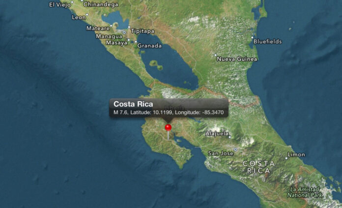
7,9 later updated at 7,6 by USGS magnitude Earthquake hits Costa Rica and it was centered 140 km west of San Jose.Costa Rica earthquake was 41 km deep.People are in panic and they are pouring out of buildings.Tsunami warning is in effect.
CNN – Earthquake 7,6 Costa Rica – VIDEO
CNN – An earthquake with a magnitude of 7.6 struck off the coast of Costa Rica Wednesday, the U.S. Geological Survey said.
The quake struck off of Costa Rica’s Pacific coast, about 87 miles west of the capital, San Jose. It was centered more than 28 miles deep. The Geological Survey originally measured the quake at magnitude 7.9, but revised it downward.
The epicenter was just six miles away from the city of Hojancha
“Earthquakes of this size have the potential to generate a widespread destructive tsunami that can affect coastlines across the Caribbean region,” the U.S. government said.
Authorities issued tsunami warnings for much of the Pacific coastlines of Costa Rica, Panama and Nicaragua, according to the Pacific Tsunami Warning Center. The warning was canceled for other locations.
An earlier tsunami watch for the Caribbean was sent out inadvertently and subsequently retracted.
CNN affiliate Teletica showed people streaming out of buildings after the quake.
Telephone service was knocked out in the cities near the epicenter, Teletica reported.
7.6 Mww – COSTA RICA
Preliminary Earthquake Report
Magnitude 7.6 Mww
Date-Time
5 Sep 2012 14:42:10 UTC
5 Sep 2012 08:42:10 near epicenter
5 Sep 2012 15:42:10 standard time in your timezone
Location 10.120N 85.347W
Depth 40 km
Distances
60 km (38 miles) SSE (167 degrees) of Liberia, Costa Rica
127 km (79 miles) SSW (209 degrees) of San Carlos, Nicaragua
141 km (88 miles) W (276 degrees) of SAN JOSE, Costa Rica
Location Uncertainty Horizontal: 13.6 km; Vertical 6.2 km
Parameters Nph = 737; Dmin = 136.0 km; Rmss = 1.42 seconds; Gp = 17°
M-type = Mww; Version = F
Event ID us c000cfsd
For updates, maps, and technical information, see:
Event Page
or
USGS Earthquake Hazards Program
National Earthquake Information Center
U.S. Geological Survey
http://neic.usgs.gov/
Later updated by USGS:
This month there were four earthquakes above 7 magnitude:
| Location Click event below for details |
Time UTC |
Lat | Lon | D km |
|
|---|---|---|---|---|---|
| 7.6 | 10km NE of Hojancha, Costa Rica | 2012-09-05 14:42:10 | 10.120°N | 85.347°W | 40.8 |
| 6.4 | 244km S of Sidorukun, Indonesia | 2012-09-03 18:23:04 | 10.785°S | 113.880°E | 8.8 |
| 7.6 | 96km E of Sulangan, Philippines | M2012-08-31 12:47:34 | 10.838°N | 126.704°E | 34.9 |
| 6.8 | 99km NW of Olonkinbyen, Svalbard and Jan Mayen | 2012-08-30 13:43:24 | 71.461°N | 10.919°W | 9.9 |
| 4.1 | 3km NE of Yorba Linda, California | 2012-08-29 20:31:00 | 33.907°N | 117.787°W | 9.1 |
| 7.3 | 131km S of Puerto El Triunfo, El Salvador | 2012-08-27 04:37:18 | 12.092°N | 88.590°W | 28.0 |
| 5.5 | 5km NNW of Brawley, California | 2012-08-26 20:57:58 | 33.024°N | 115.549°W | 9.0 |
| 5.3 | 4km NNW of Brawley, California | 2012-08-26 19:31:22 | 33.019°N | 115.546°W | 12.3 |
| 6.6 | 140km WNW of Tobelo, Indonesia | 2012-08-26 15:05:37 | 2.197°N | 126.835°E | 91.9 |
| 6.3 | 53km SSE of Palu, Indonesia | 2012-08-18 09:41:52 | 1.318°S | 120.102°E | 10.0 |
| 7.7 | 158km ENE of Poronaysk, Russia | 2012-08-14 02:59:42 | 49.784°N | 145.126°E | 625.9 |
| 6.2 | 30km WSW of Ahar, Iran | 2012-08-11 12:34:35 | 38.390°N | 46.741°E | 11.0 |
Source:
http://earthquake.usgs.gov/earthquakes/map/
http://edition.cnn.com/2012/09/05/world/americas/costa-rica-earthquake/index.html?hpt=hp_t1
TBU NEWS


