UK is preparing for the cold Arctic weather that is going to impact UK soon and rest of the Europe is also awaiting the next week breeze, starting Sunday.
Nasa predicts ‘weather chaos’ for 2016
The water story for much of the American West over most of the past decade has been dominated by punishing drought,’ said JPL climatologist Bill Patzert.
‘Reservoir levels have fallen to record or near-record lows, while groundwater tables have dropped dangerously in many areas.
‘Now we’re preparing to see the flip side of nature’s water cycle — the arrival of steady, heavy rains and snowfall.’


In 1982-83 and 1997-98, large El Niños delivered about twice the average amount of rainfall to Southern California, along with mudslides, floods, high winds, lightning strikes and high surf. But Patzert cautioned that El Niño events are not drought busters.
‘Over the long haul, big El Niños are infrequent and supply only seven percent of California’s water,’ he said.
‘Looking ahead to summer, we might not be celebrating the demise of this El Niño,’ cautioned Patzert.
‘It could be followed by a La Niña, which could bring roughly opposite effects to the world’s weather.’
La Niñas are essentially the opposite of El Niño conditions. During a La Niña episode, trade winds are stronger than normal, and the cold water that normally exists along the coast of South America extends to the central equatorial Pacific.
La Niña episodes change global weather patterns and are associated with less moisture in the air over cooler ocean waters.
This results in less rain along the coasts of North and South America and along the central and eastern equatorial Pacific, and more rain in the far Western Pacific.
El Niño events are part of the long-term, evolving state of global climate, for which measurements of sea surface height are a key indicator.
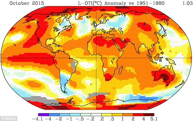
Global temperatures have already smashed records this year, and now meteorologists are warning 2016 will be even hotter.
The annual global temperature forecast from the Met Office suggests 2016 will be between 0.72°C and 0.95°C above the long-term average of 14°C.
Professor Chris Folland, Met Office research fellow, said: ‘2015 is on track to be the warmest year on record, and this forecast suggests 2016 is likely to be as warm, if not warmer.’
The forecast for 2016 is higher than the predictions for 2015 made a year ago, which suggested temperatures would be 0.52°C to 0.76°C above the 1961 to 1990 long-term average.
The latest data for 2015 suggests it is 0.72°C above the average, making it the hottest year on record.
With 2014 also one of the hottest on record, Professor Adam Scaife, head of long range prediction at the Met Office, said: ‘This forecast suggests that by the end of 2016 we will have seen three record, or near-record, years in a row for global temperatures.’
The Met Office said it does not expect the record-breaking run to continue indefinitely, but it shows how global warming can combine with smaller, natural fluctuations such as El Nino to push the climate to unprecedented levels of warmth.
Experts previously warned global average surface temperatures in 2015 are likely to reach what they call the ‘symbolic and significant milestone’ of 1°C (33°F) above the pre-industrial era.
WMO director-general Michel Jarraud believes El Niño may be responsible for 16 to 20 per cent of the rise, and longer-term averages show temperatures rising regardless of El Niño or its cooling counterpart La Niña.
NASA Examines Global Impacts of the 2015 El Niño
People all over the world are feeling, or will soon feel, the effects of the strongest El Niño event since 1997-98, currently unfolding in the eastern equatorial Pacific Ocean. New NASA satellite observations are beginning to show scientists its impact on the distribution of rain, tropospheric ozone and wildfires around the globe.
New results presented Tuesday, Dec. 15, at the American Geophysical Union meeting in San Francisco show that atmospheric rivers, significant sources of rainfall, tend to intensify during El Niño events, and this year’s strong El Niño likely will bring more precipitation to California and some relief for the drought. Atmospheric rivers are short-lived, narrow streams of wind that carry water vapor from the tropical oceans to mid-latitude land areas.
Due to this El Niño, tropospheric ozone, a pollutant and greenhouse gas, is seen decreasing over mid-latitude locations such as the United States, and the risk of fires across the tropics is showing signs of increasing.
An El Niño, which is a reoccurring natural phenomenon, happens when sea surface temperatures in the equatorial Pacific Ocean warm up. The increased ocean surface temperatures influence air and moisture movement around the globe. Approximately 15 years of observations by NASA’s fleet of Earth-observing satellites show how El Niños affect multiple interconnected Earth systems.
One big question about the current El Niño is whether it will bring significant rainfall to drought-plagued California. Researchers studying storms and their relationship to strong El Niños believe it will.
Duane Waliser, chief scientist of the Earth Science and Technology Directorate at NASA’s Jet Propulsion Laboratory in Pasadena, California, and his colleagues analyzed the historical record of atmospheric rivers. These concentrated rain bands account for 40 percent of California’s water supply. Their results suggest the number of atmospheric rivers California receives will remain the same, at an average of 10 per year, but they will be stronger, warmer and wetter.
“Overall, we’ll likely get more precipitation, but maybe less in terms of snowfall,” Waliser said, adding that atmospheric rivers may contribute to more flooding.
It’s the strength of the El Niño that determines its impact on total rainfall in California, said Martin Hoerling, a research meteorologist with the Earth Systems Research Laboratory at the National Oceanic and Atmospheric Administration in Boulder, Colorado. His group ran a statistical analysis of the relationship between past El Niño strength and precipitation.
“What we learned is weak El Niños don’t necessarily change the odds of precipitation being much different from normal,” said Hoerling. “The rare occurrence of a strong El Niño, like what we’re currently experiencing, however, greatly increases the odds of a wet California winter.”
El Niño’s elevated sea surface temperatures shift rain patterns by affecting the temperature of the air above the ocean, which alters how winds and air masses circulate air around the planet.
The change in winds also affects the distribution of tropospheric ozone around the planet. Tropospheric ozone exists in the atmospheric layer closest to the surface and comprises ozone produced naturally and from human pollution. Ozone in the troposphere is a greenhouse gas and a health hazard. Understanding El Niño’s influence on ozone concentration is important for understanding the atmosphere’s response to natural variation and distinguishing natural changes from human causes.
Mark Olsen, an atmospheric research scientist at Morgan State University in Baltimore and NASA’s Goddard Space Flight Center in Greenbelt, Maryland, and his colleagues produced the first near-global map of ozone sensitivity caused by El Niño and La Niña events. Previous work showed that El Niño events cause a strong change in ozone in the tropics. Olsen’s new work uses satellite data, combined with a computer model, to show that a smaller but still significant effect occurs in the mid-latitudes.
“El Niño is just one factor in the variability,” Olsen said. “But you do see regions like the central United States where El Niño explains 20 to 25 percent of the variability.”
Ozone in this region tends to decrease where El Niño-driven changes to local wind circulation patterns cause them to draw air upward. According to Olsen, it’s a large enough influence that El Niño does need to be considered if you want to attribute causes of ozone concentration changes and long-term trends.
Jim Randerson, Earth system scientist at the University of California, Irvine, and his team analyzed wildfire burned-area maps from satellite data to study how El Niño-driven effects change the distribution and severity of wildfires worldwide. During El Niños, the number and size of fires increases in tropical forests across Asia and South America.
“The change in atmospheric dynamics shifts the rainfall,” Randerson said. “So El Niño causes less rain to fall in many areas of the tropics, making forests more vulnerable to human-ignited fires.”
Fires in tropical forests also accelerate carbon dioxide buildup in the atmosphere and reduce air quality. Indonesia, for example, has carbon-rich peatlands that ignite as soon as the rain stops, which is what happened this fall, Randerson said. Meanwhile, Southeast Asia, Central America and the southern Amazon have very high fire risk for 2016. El Niño tends to reduce rainfall in their wet seasons, and less rain means drier vegetation and drier air, which make forests vulnerable to dry season burning.
NASA uses the vantage point of space to increase our understanding of our home planet, improve lives, and safeguard our future. NASA develops new ways to observe and study Earth’s interconnected natural systems with long-term data records. The agency freely shares this unique knowledge and works with institutions around the world to gain new insights into how our planet is changing.
How NASA sees El Nino effects from space
This winter, weather patterns may be fairly different than what’s typical—all because of unusually warm ocean water in the east equatorial Pacific, an event known as El Niño. Because of El Niño, California is expected to get more rain while Australia is expected to get less. Since this El Niño began last summer, the Pacific Ocean has already experienced an increase in tropical storms and a decrease in phytoplankton.
El Niño is an irregularly occurring weather phenomenon created through an abnormality in wind and ocean circulation. While it originates in the equatorial Pacific Ocean, El Niño has wide-reaching effects. In a global context, it affects rainfall, ocean productivity, atmospheric gases and winds across continents. At a local level, it influences water supplies, fishing industries and food sources.
With its scientific expertise and more than a dozen Earth-observing satellites, NASA is a leader in observing the local and global effects of El Niño. NASA data helps scientists learn more about the mechanics of an El Niño event, the interconnectedness of Earth’s climate and weather systems and how our daily lives are affected by this periodic climate event.
Discover some of El Niño’s key impacts and how NASA studies them from space:
Rainfall
El Niño often spurs a change in rainfall patterns that can lead to major flooding, landslides and droughts across the globe.
In normal, non-El Niño conditions, Pacific trade winds near the equator blow from east to west—from South America to Southeast Asia—moving warm surface water with them. The warm ocean water evaporates, adds moisture to the air and produces annual monsoons in the South Asian region. When the trade winds stop and move back east during an El Niño, water near Southeast Asia and Australia is cooler than normal, often leading to drought. Water also remains warm near South America and often spurs storms and flooding. During an El Niño, California and the Southern United States also tend to receive more rain.
The Global Precipitation Measurement mission (GPM), a joint effort of NASA and Japan Aerospace eXploration Agency, tracks precipitation worldwide and creates global precipitation maps updated every half-hour using data from a host of satellites. Scientists use the satellite data to study changes in rain and snow patterns and gain a better understanding of Earth’s climate and weather systems.
Hurricanes
El Niño also influences the formation of tropical storms. El Niño events are associated with fewer hurricanes in the Atlantic but more hurricanes and typhoons in the Pacific.
Tropical cyclones typically grow stronger as they travel over warm water and dissipate over cold water. During El Niño, normal upwelling—the processes that brings colder, deeper water to the ocean surface—is suppressed in the east equatorial Pacific. As a result, the average temperature in the Pacific is warmer than normal and aids the formation of tropical storms.
The 2015 hurricane season in the North Pacific was particularly busy, partially due to this year’s El Niño. NASA has a suite of instruments in space that can study various aspects of storms, such as rainfall activity, cloud heights, surface wind speed and ocean heat. The Moderate Resolution Imaging Spectroradiometer (MODIS) instrument on NASA’s Terra satellite captured an image of Hurricane Patricia— the ninth hurricane in the eastern Pacific to reach category 4 or 5 status during the 2015 season.
Ocean ecology
While El Niño affects land, it also impacts the marine food web, as evidenced in the color of the ocean— the hue of the water hue influenced by the presence of tiny plants, sediments and colored dissolved organic material. During El Niño, fisheries collapse and animals up the food chain starve, specifically in the east equatorial Pacific Ocean.
Under normal, non-El Niño conditions, deep ocean waters upwell in the eastern Equatorial Pacific bringing nutrient-rich, cold water to the surface. When the water reaches the surface, this combination of abundant nutrients and sunlight helps phytoplankton—microscopic algae that form the base of the marine food web— to grow. During El Niño conditions, upwelling is suppressed and the deep, nutrient-rich waters no longer reach the surface, causing less phytoplankton productivity. With less food, the fish population declines, severely affecting fishing industries.
NASA satellites measure the color of the ocean to derive surface chlorophyll, a pigment in phytoplankton vital for photosynthesis, and observe lower total chlorophyll amounts during El Niño events in the equatorial Pacific Ocean. In the visualization below from NASA’s Sea-Viewing Wide Field-of-View Sensor (SeaWIFS) instrument, there is a decline in phytoplankton during the El Niño of 1997-‘98 and an increase during the La Niña event of 1998-99. Scientists will continue to use SeaWIFS to monitor the ocean color during this current El Niño season.
Ozone
El Niño also influences ozone— a compound that plays an important role in the Earth system and human health. At ground level, ozone affects air quality. Higher in Earth’s atmosphere in a layer known as the troposphere, ozone is a greenhouse gas, which stops some of the heat from escaping to space and keeps the surface warm.
When a strong El Niño occurs, there is a substantial change in the major east-west tropical circulation, causing a significant redistribution of atmospheric gases like ozone. These changes occur vertically throughout the troposphere and cause higher ozone levels over Indonesia and lower levels over much of the tropical central and eastern Pacific Ocean during an El Niño.
Scientists use NASA’s Aura satellite to measure ozone concentrations in the troposphere. With more than a decade of Aura data, researchers are able to separate the response of ozone concentrations to an El Niño from its response to changes in human activity, such as manmade fires.
Most ozone is found in Earth’s stratosphere—higher than where most planes fly—where it acts as a shield that absorbs and screens humans from most harmful ultraviolet light from the sun. NASA has been monitoring stratospheric ozone and the ozone layer via satellite starting in the late 1970s and continues to make measurements with the Aura satellite as well as Suomi National Polar-orbiting Partnership, a joint satellite mission with the National Oceanic and Atmospheric Administration. Although El Niño has a greater effect on ozone in the troposphere, scientists are learning how it also modifies ozone concentrations in the stratosphere, sometimes changing concentrations in the tropics by about 15 percent.
Fires
El Niño conditions shift patterns of rainfall and fire across the tropics. During El Niño years, the number and intensity of fires increases, especially under drought conditions in regions accustomed to wet weather. During past El Niño events, Indonesia, Central America and the southern and central Amazon experienced more fire activity than normal.
While fires damage rainforests, croplands and grazing lands, they also emit greenhouse gases—carbon dioxide and methane—that trap heat in the atmosphere and contribute to global warming. For instance, during the 2002 and 2006 El Niño events, fire emissions in equatorial Asia increased by a factor of 10 compared to normal years.
NASA’s MODIS instruments on Aqua and Terra satellites provide a global picture of fire activity. MODIS was specifically designed to observe fires, allowing scientists to discern flaming from smoldering burns. The long time series of MODIS data (2000-present) now covers a strong El Niño event, linking estimates of changing fire activity to the amounts of particles and gases that fires release into the atmosphere.
For updates, visit NASA Center for Climate Sciences: El Nino Observations page:
http://climatesciences.jpl.nasa.gov/enso
For the latest imagery, visit NASA’s El Nino/La Nina Watch page:
https://sealevel.jpl.nasa.gov/science/elninopdo/latestdata/
By NASA
Best Regards
TBU NEWS


